





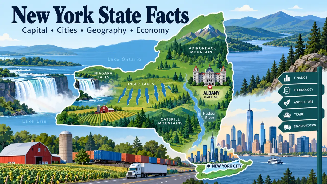
New York State is often pictured through New York City – skyscrapers, Wall Street, Broadway and millions of people packed into a small part of the state. That picture is important, but it is far from complete. New York stretches from the Atlantic coast and Long Island to the Canadian border and from the Hudson Valley west to Lake Erie.
Across that distance are the Adirondack and Catskill mountains, the Finger Lakes, major river valleys, productive farmland, forests, Great Lakes shorelines and cities with very different histories and economies. Albany is the capital, while New York City is the largest city.
This guide looks at New York State as a whole – its geography, capital, major cities, population, economy, GDP, history, government, education, landmarks and state symbols. It is designed as a reference for students, teachers, quiz learners and anyone who wants to understand how the different parts of New York fit together.
Quick Facts About New York State
| Fact | New York State |
|---|---|
| Official name | State of New York |
| Postal abbreviation | NY |
| Capital | Albany |
| Largest city | New York City |
| U.S. region | Northeastern United States |
| Statehood | July 26, 1788 |
| Order of statehood | 11th |
| Land area | 47,123.4 square miles |
| Water area | 7,435.1 square miles |
| Total area | About 54,558.5 square miles |
| Population | 20,002,427 – July 1, 2025 Census estimate, Vintage 2025 |
| Population rank | 4th – July 1, 2025 Census estimates |
| Approximate population density | About 424.5 people per square mile of land, using the 2025 population estimate |
| Counties | 62 |
| Nickname | The Empire State |
| Words on the current state arms | “Excelsior” and “E pluribus unum” |
| Highest point | Mount Marcy – 5,344 feet |
| Great Lakes bordering the state | Lake Erie and Lake Ontario |
| Time zone | Eastern Time |
| State bird | Eastern bluebird |
| State mammal | Beaver |
| State flower | Rose |
| State tree | Sugar maple |
The U.S. Census Bureau estimated New York’s population at 20,002,427 on July 1, 2025. In the same Vintage 2025 series, California, Texas and Florida ranked ahead of New York in population.
New York State and New York City Are Not the Same Thing
This distinction is simple but important. New York State is one of the 50 U.S. states. New York City is one city within that state.
New York City contains five boroughs – Manhattan, Brooklyn, Queens, the Bronx and Staten Island – and is the state’s largest population and economic center. Albany, however, is the state capital. Buffalo, Rochester, Syracuse, Yonkers and many other communities are also part of New York State.
The Census Bureau estimated New York City’s population at 8,584,629 on July 1, 2025. Compared with the statewide estimate of 20,002,427, the city accounted for about 43% of New York State’s population. In other words, most New York State residents lived outside New York City.
Where Is New York State Located?
New York is in the northeastern United States. Its location connects several major geographic areas: New England lies to the east, the Mid-Atlantic states lie to the south, the Great Lakes are to the west, and Canada lies to the north.
The southeastern part of the state reaches the Atlantic Ocean through New York City and Long Island. Western New York borders Lake Erie and Lake Ontario, while northern New York extends through the Adirondacks to the Canadian border.
What States Border New York?
New York has land borders with five states: Pennsylvania, New Jersey, Connecticut, Massachusetts and Vermont. It also shares an international boundary with the Canadian provinces of Ontario and Quebec. Census geographic profiles also list Rhode Island as bordering New York because the two states share a water boundary.
The long southern boundary with Pennsylvania separates much of New York’s Southern Tier from its neighbor. New Jersey borders the southeastern part of the state and is closely tied to the New York City metropolitan area. To the east, Connecticut, Massachusetts and Vermont mark the transition toward New England.
How Large Is New York State?
The Census Bureau reports 47,123.4 square miles of land and 7,435.1 square miles of water in New York. Together, that is about 54,558.5 square miles.
Those figures also show why land area and total area should not be treated as the same measurement. New York contains substantial water area because of the Great Lakes, inland lakes, rivers and coastal waters.
Geography of New York State
New York’s physical geography helps explain where its cities developed, why certain transportation routes became important, where farming is concentrated and why weather can differ sharply across the state.
Major Geographic Regions
Northern New York contains the Adirondack Mountains and large areas of forest and lakes. The Catskills rise west of the Hudson River farther south. Between and around these higher areas are major valleys and lowlands that have long provided routes for settlement and transportation.
The Hudson Valley runs north-south through eastern New York. Near Albany, the Mohawk Valley opens westward across the state. That natural corridor later became especially important for the Erie Canal, railroads and highways because it provided a practical route between the Hudson River system and western New York.
Central and western New York include the Finger Lakes, agricultural areas and cities such as Syracuse, Rochester and Buffalo. Long Island and the New York City area form a very different southeastern landscape shaped by the Atlantic coast, New York Harbor and Long Island Sound.
Adirondack and Catskill Mountains
The Adirondack Mountains cover a large part of northern New York. They include the state’s highest peaks and extensive forests, lakes and wilderness areas.
Mount Marcy, in the Adirondack High Peaks, reaches 5,344 feet above sea level and is the highest point in New York State.
The Adirondacks should not simply be described as another branch of the Appalachian Mountains. Their geology is distinct. The Catskills, by contrast, are part of the broader Appalachian region even though their landscape has its own character.
Major Rivers
The Hudson River is one of the most important geographic features in New York history. It flows generally south through eastern New York toward New York Harbor. The river helped shape trade, military strategy, settlement and transportation.
The Mohawk River joins the Hudson near the Capital Region. Its valley created a useful east-west passage through the state’s uplands. That geographic advantage later helped determine the path of the Erie Canal and major transportation routes.
Other important rivers include the St. Lawrence River along part of the Canadian boundary, the Niagara River between Lake Erie and Lake Ontario, the Genesee River in western New York and portions of the Delaware and Susquehanna river systems.
Great Lakes and Finger Lakes
New York borders two of the five Great Lakes – Lake Erie and Lake Ontario. The Niagara River carries water from Lake Erie toward Lake Ontario, with Niagara Falls located along that river at the international boundary.
The Finger Lakes are a group of long, narrow lakes in west-central New York. Continental glaciers helped deepen and reshape their valleys during the Ice Age. Seneca and Cayuga are among the best known.
Lake Champlain lies along the northeastern boundary between New York and Vermont and continues north toward Canada. Its position made it an important transportation and military corridor at several points in history.
Long Island and the Coast
Long Island extends eastward into the Atlantic Ocean. Brooklyn and Queens occupy its western portion, while Nassau and Suffolk counties cover the remainder.
The southeastern part of New York also includes New York Harbor, Long Island Sound, beaches, bays, wetlands and barrier islands. This coastal geography helps moderate temperatures compared with colder inland and northern parts of the state.
Climate of New York State
New York has four distinct seasons, but there is no single climate description that fits every part of the state equally well.
Western New York is strongly influenced by Lake Erie and Lake Ontario. In winter, cold air passing over relatively warmer lake water can absorb moisture and produce narrow bands of heavy lake-effect snow.
The Adirondacks and other high-elevation northern areas generally have colder and longer winters. The Hudson Valley has its own local temperature and precipitation patterns because of terrain and elevation. New York City and Long Island tend to have milder winters than much of inland and northern New York because of their southerly and coastal location.
How Geography Shaped New York
The geography of New York is not just a collection of mountains, rivers and lakes. It helped determine the state’s history.
The Hudson gave ships access deep into the interior. The Mohawk Valley provided a route west. The Great Lakes connected New York with the interior of North America. Fertile valleys and lake plains supported agriculture. New York Harbor gave the state direct access to Atlantic trade.
When engineers built the Erie Canal through this existing geographic corridor, they turned a natural advantage into an economic one. The same general routes later attracted railroads, highways, cities and industries.
What Is the Capital of New York State?
Albany is the capital of New York State. New York City is the state’s largest city, but it is not the capital.
Albany stands on the west bank of the Hudson River in eastern New York. Its position near the meeting of the Hudson and Mohawk transportation corridors helped make it an important settlement, trading center and government location.
Why Is Albany the Capital Instead of New York City?
New York’s government met in several places during the Revolutionary and early statehood periods. Kingston served as the first capital of independent New York in 1777. Albany became the permanent capital in 1797.
Albany’s location made sense for a state whose population and territory extended far beyond the port city of New York. It sat on the Hudson River and near the route leading west through the Mohawk Valley. New York City later became enormously larger and more economically powerful, but Albany remained the seat of state government.
Major Cities in New York State
The following figures use the U.S. Census Bureau’s July 1, 2025 Vintage 2025 population estimates so that the cities are being compared with the same dataset and reference date.
| City | July 1, 2025 population estimate | Region | Why it matters |
|---|---|---|---|
| New York City | 8,584,629 | Southeastern New York | Finance, trade, media, technology, culture and transportation |
| Buffalo | 274,613 | Western New York | Great Lakes trade, healthcare, education and manufacturing |
| Yonkers | 212,603 | Lower Hudson Valley | Major city within the New York metropolitan area |
| Rochester | 206,108 | Finger Lakes region | Healthcare, education, optics, imaging and manufacturing |
| Syracuse | 144,896 | Central New York | Education, healthcare, transportation and industry |
| Albany | 101,698 | Capital Region | State government, education and regional technology activity |
New York City
New York City is by far the largest city in the state. Its five boroughs form the core of a large metropolitan area that crosses state lines. The city is internationally important in finance, media, culture, higher education, technology, tourism and trade.
Its size can make it easy to forget that it occupies only a small part of New York State geographically. Much of the state’s land, agriculture, forests, mountains and freshwater resources lie outside the city.
Buffalo
Buffalo sits at the eastern end of Lake Erie near the Niagara River and Canadian border. Its location became especially valuable after the Erie Canal opened, making the city an important point where Great Lakes traffic connected with routes to the Hudson River and Atlantic coast.
Yonkers
Yonkers is in Westchester County directly north of New York City. It is closely tied to the larger metropolitan economy through commuting, transportation and commerce while remaining a separate city along the Hudson River.
Rochester
Rochester grew as a manufacturing center and became especially well known for photography, imaging and optics. Healthcare, universities, research and technology now make up important parts of its economy.
Syracuse
Syracuse is a major center of Central New York. Historic canal and rail routes helped the city grow, while education, healthcare and manufacturing remain important to the modern regional economy.
Albany
Albany is smaller than several other New York cities, but population size does not determine political importance. As the state capital, it is the center of New York State government. The surrounding Capital Region also includes universities, research centers and technology-related industries.
Population of New York State
The U.S. Census Bureau estimated New York’s population at 20,002,427 on July 1, 2025. In the same Vintage 2025 dataset, New York ranked fourth among the states, behind California, Texas and Florida.
Census Count vs. Population Estimate
A Census count and a population estimate are not the same thing. The decennial census attempts to count the population once every 10 years. Annual population estimates use births, deaths, migration and other administrative data to estimate changes between censuses.
The 2020 Census counted 20,201,249 people in New York. The Census Bureau’s Vintage 2025 estimates use an April 1, 2020 estimates base of 20,203,696 and estimate 20,002,427 residents on July 1, 2025 – a decline of about 1.0% from that estimates base.
There is another detail researchers should watch: each annual “vintage” can revise estimates for earlier years. The Census Bureau says old vintages are superseded when a new series is released. For year-to-year comparisons, figures should therefore come from the same vintage. In Vintage 2025, New York’s July 1 population was estimated at 20,001,419 in 2024 and 20,002,427 in 2025, meaning the estimate was nearly flat over that one-year period.
New York City and the Rest of the State
New York City’s July 1, 2025 population estimate was 8,584,629. That was about 42.9% of the statewide estimate.
This helps correct a common misconception. New York City contains an unusually large share of the state’s residents, but more than half of New York State’s population lives elsewhere.
Urban, Suburban and Rural New York
Settlement patterns vary sharply across New York. New York City is extremely dense, and its suburbs extend through Long Island and the lower Hudson Valley. Buffalo, Rochester, Syracuse and Albany anchor other metropolitan areas.
At the same time, large parts of the Adirondacks, Catskills, North Country and Southern Tier are lightly populated. Farming communities and small towns cover significant areas of central and western New York. Describing all land outside New York City as “rural” would therefore be misleading – upstate New York includes major cities, suburbs, small towns, farmland and wilderness.
Economy of New York State
New York has one of the largest state economies in the United States. Finance is famous because of Wall Street, but New York’s economy is much broader. Healthcare, education, professional services, trade, transportation, tourism, information, manufacturing, technology and agriculture all contribute.
Economic activity also differs by region. New York City has an unusually large concentration of finance, media and professional services. The Capital Region has government, education and technology-related research. Rochester has strengths in healthcare, education, optics and imaging. Buffalo and western New York combine healthcare and education with manufacturing, logistics and cross-border trade. Rural areas support agriculture, forestry and tourism.
Employment by Major Industry Group
The Bureau of Labor Statistics reported about 9.96 million nonfarm payroll jobs in New York in July 2026 on a seasonally adjusted, preliminary basis. The table below shows several broad industry groups.
| Industry group | July 2026 payroll employment |
|---|---|
| Education and health services | About 2.42 million |
| Government | About 1.53 million |
| Trade, transportation and utilities | About 1.48 million |
| Professional and business services | About 1.41 million |
| Leisure and hospitality | About 920,000 |
| Financial activities | About 761,000 |
| Manufacturing | About 397,000 |
| Information | About 275,000 |
Employment size and GDP contribution are not the same measurement. An industry can employ many people without producing the largest share of GDP, while another can generate high economic output with fewer workers. This is one reason economic articles should not use employment rankings as if they were GDP rankings.
Finance and Professional Services
New York City is one of the world’s major financial centers. Banking, securities, insurance, asset management, accounting, law, consulting and related professional services contribute heavily to the state’s economic output.
That does not mean finance represents the entire state economy. Many areas outside New York City depend more heavily on healthcare, education, manufacturing, government, agriculture or tourism.
Healthcare and Education
Healthcare and education are especially important because they are spread throughout the state. Hospitals, medical practices, nursing facilities, schools, colleges and universities provide employment in large cities as well as smaller regional centers.
The July 2026 BLS data show education and health services as the largest broad private-sector employment group in New York, with about 2.42 million payroll jobs.
Technology, Research and Advanced Industry
Technology activity is not limited to one place. New York City has a large software, digital-media and technology sector. Universities and research institutions across the state support science and engineering. The Capital Region has developed semiconductor and nanotechnology research activity, while Rochester has long-standing expertise in optics, imaging and photonics.
Manufacturing and Logistics
Manufacturing has a smaller employment share than it did during New York’s industrial peak, but it remains important. Food processing, machinery, chemicals, pharmaceuticals, electronics, aerospace-related products and advanced manufacturing are among the activities found across the state.
Geography still matters. Great Lakes access, Canadian border crossings, the Hudson corridor, interstate highways, railroads, airports and New York Harbor support transportation and logistics.
Agriculture in New York State
New York’s large cities can hide the scale of its agricultural landscape. USDA’s 2025 State Agriculture Overview reported about 30,000 farm operations covering 6.4 million acres.
| Agricultural measure | 2025 figure |
|---|---|
| Farm operations | 30,000 |
| Land operated by farms | 6.4 million acres |
| Milk production | 16.568 billion pounds |
| Value of milk production | About $3.61 billion |
| Apples utilized | About 1.494 billion pounds |
| Grapes produced | 195,500 tons |
| Maple syrup | 829,000 gallons |
Dairy farming is especially important. Apples, grapes, corn, hay, vegetables and maple products also help show how different New York’s rural economy is from the financial image associated with Manhattan.
Tourism
Tourism also has a statewide footprint. New York City draws international visitors, while Niagara Falls, the Adirondacks, Catskills, Finger Lakes, Hudson Valley, historic sites and Long Island beaches support travel in other regions.
GDP of New York State
Gross domestic product, or GDP, measures the value of goods and services produced within an economy. State GDP allows economists to compare the size and growth of state economies.
U.S. Bureau of Economic Analysis data released in April 2026 put New York’s 2025 current-dollar GDP at about $2.468 trillion. In that same annual dataset, California was about $4.251 trillion and Texas about $2.904 trillion. That placed New York third among the states by current-dollar GDP for 2025.
Current-Dollar GDP vs. Real GDP
Current-dollar GDP measures output using prices from the period being measured. Because prices can rise over time, current-dollar GDP can increase even when part of the increase comes from inflation.
Real GDP adjusts for price changes. BEA’s annual series put New York’s real GDP at about $1.894 trillion in chained 2017 dollars in 2025, compared with about $1.840 trillion in 2024. That represents roughly 2.9% real growth between the two annual estimates.
What Does a Quarterly GDP Number Mean?
BEA also publishes quarterly state GDP. The latest state GDP release available as of September 13, 2026 covers the first quarter of 2026. New York’s Q1 2026 current-dollar GDP was reported at a seasonally adjusted annual rate of about $2.554 trillion.
That figure should not be confused with the annual 2025 GDP total. A seasonally adjusted annual rate expresses the quarter at an annualized pace; it is not the amount of output produced during that quarter alone.
BEA’s next state GDP release is scheduled for September 30, 2026. If this article is updated after that date, the GDP figures should be checked again because BEA data are revised as new information becomes available.
GDP Is Not the Same as Income
A large state GDP does not mean every resident earns a large income. GDP measures economic production. Personal income, wages, median household income and per capita income measure different things. Keeping those measures separate is essential when comparing state economies.
Brief History of New York State
Indigenous Peoples Before European Colonization
Human history in New York did not begin with European exploration. The New York State Museum reports that Indigenous people have lived in what is now New York for at least 13,000 years.
Haudenosaunee nations have deep homelands across much of upstate New York. The original Haudenosaunee Confederacy joined the Mohawk, Oneida, Onondaga, Cayuga and Seneca nations; the Tuscarora later became its sixth nation. Indigenous peoples including the Lenape, Shinnecock and Unkechaug also have long histories connected with the lower Hudson Valley, Long Island and surrounding regions.
These were organized societies with political institutions, agriculture, trade networks, languages and cultural traditions. Indigenous communities continue to live in New York today. The New York State Museum notes that eight federal and state recognized sovereign Indigenous nations are located in what is now New York.
New Netherland and New Amsterdam
During the 17th century, the Dutch established the colony of New Netherland. Its settlements included New Amsterdam at the southern end of Manhattan and communities farther north along the Hudson River, including the area that became Albany.
The Hudson River gave Dutch traders access to the interior, and the fur trade became especially important. This colonial economy depended heavily on relationships and conflicts with Indigenous peoples whose homelands the newcomers were entering.
English Control and the Name New York
English forces took control of New Netherland in 1664. New Amsterdam became New York, named for the Duke of York, and the wider colony also came under the New York name.
Dutch influence did not disappear immediately. Families, place names, farms, trading networks and cultural traditions continued to shape parts of the colony long after the political transfer.
New York and the American Revolution
New York’s geography made it strategically important during the American Revolution. British forces occupied New York City for much of the war, while both sides understood that control of the Hudson River corridor could affect movement between New England and the rest of the colonies.
The American victory at Saratoga in 1777 became a major turning point because it helped persuade France to enter the war openly on the American side.
The war also divided Haudenosaunee communities. Several nations and communities supported the British, while the Oneida and Tuscarora provided significant support to the American cause. Warfare and retaliatory campaigns caused severe destruction and displacement across Haudenosaunee homelands. This history is more complicated than saying that the Haudenosaunee as a whole supported one side.
Statehood and the Early United States
New York ratified the U.S. Constitution on July 26, 1788, becoming the 11th state. Readers comparing New York with the rest of the country can also review how many states are in the United States.
New York City became an early center of the new federal government. George Washington took the presidential oath of office there in 1789. Albany became New York’s permanent state capital in 1797.
The Erie Canal Changed the State
Construction of the original Erie Canal began in 1817. When completed in 1825, it ran about 363 miles between Albany and Buffalo.
The canal linked the Hudson River corridor with Lake Erie and the Great Lakes system. Goods from the interior could move toward New York City more cheaply, while manufactured goods and settlers moved west. Buffalo, Rochester, Syracuse and communities along the route grew as transportation and trade expanded.
This is a clear example of geography and economics working together: the Hudson and Mohawk valleys created a favorable route, and the canal turned that route into a much more efficient transportation system.
Reform Movements and Seneca Falls
New York also became an important center of 19th-century reform movements, including abolition, temperance and women’s rights.
On July 19 and 20, 1848, several hundred people gathered at Seneca Falls for the first convention organized specifically to discuss women’s social, civil and religious rights. The meeting adopted the Declaration of Sentiments and became a major landmark in the history of the American women’s rights movement.
Transportation mattered here too. Canals, roads and railroads helped people, newspapers and political ideas move through central and western New York. The same networks that moved goods also helped reform movements spread.
Abolition and Harriet Tubman
New York communities also played important roles in antislavery activism and the Underground Railroad. Harriet Tubman settled in Auburn in 1859 and lived there for much of the rest of her life. Frederick Douglass published and spoke from Rochester, making western New York another important center of abolitionist activity.
Immigration and Industrial Growth
During the 19th and early 20th centuries, New York Harbor became one of the main gateways for immigrants entering the United States. New arrivals helped transform New York City and many other communities.
At the same time, canals, Great Lakes shipping and railroads supported industrial expansion across upstate New York. Buffalo became a major transportation and industrial center. Rochester developed manufacturing tied to flour milling and later photography, optics and other industries. Syracuse grew around transportation, salt production and manufacturing.
Government of New York State
New York’s state government has three branches: executive, legislative and judicial. Albany is the seat of state government.
The state legislature has two chambers – the New York State Senate and the New York State Assembly. The judicial system includes trial courts, intermediate appellate courts and the state’s highest court.
Why New York’s Court Names Can Be Confusing
New York uses court names differently from many other states. The New York Court of Appeals is the state’s highest court. The New York Supreme Court, despite its name, is primarily a trial court with broad jurisdiction.
This is a useful fact for students because “Supreme Court” usually suggests the highest court in a jurisdiction, but New York is an important exception.
Counties and Local Government
New York has 62 counties. New York City has a special structure in which each of its five boroughs corresponds to a county: Manhattan is New York County, Brooklyn is Kings County, Queens is Queens County, the Bronx is Bronx County and Staten Island is Richmond County.
Education in New York State
New York has one of the country’s largest and most varied higher-education systems, including statewide public institutions, New York City’s public university network and major private universities.
State University of New York
The State University of New York, usually called SUNY, reported 64 campuses and 387,446 students in fall 2025. Its institutions include university centers, comprehensive colleges, technology colleges and community colleges across the state.
Because SUNY campuses are spread through many regions, the system contributes not only to education but also to local research, healthcare, workforce training and regional economies.
City University of New York
The City University of New York, or CUNY, is a separate public university system centered in New York City. CUNY currently reports 26 colleges serving about 247,000 degree-seeking students.
Private Universities and Research
New York is also home to private institutions such as Columbia University, Cornell University, New York University, the University of Rochester and Syracuse University.
The significance of these institutions goes beyond enrollment. Universities support hospitals, laboratories, scientific research, arts organizations, new businesses and highly specialized workforces.
Famous Places, Natural Attractions and Landmarks
Niagara Falls
Niagara Falls lies on the Niagara River between New York and Ontario, Canada. The river carries water from Lake Erie toward Lake Ontario. The falls are both a major natural attraction and an important source of hydroelectric power in the region.
Adirondack Park
Adirondack Park covers a vast area of northern New York containing public and private lands, mountains, forests, lakes and communities. Mount Marcy and many of the state’s highest peaks are found within the Adirondack region.
Finger Lakes
The Finger Lakes combine glacial geography with agriculture, wineries, colleges, towns and recreation. Their long, narrow form makes them easy to recognize on a map of New York.
Hudson River
The Hudson is simultaneously a natural feature, transportation route and historical corridor. It connects the Albany region with New York Harbor and influenced settlement, military strategy and economic development.
Erie Canal
The Erie Canal is one of the most important engineering projects in New York history. Its opening in 1825 changed trade patterns, reduced transportation costs and helped strengthen New York City’s relationship with the interior of the country.
New York City Landmarks
The Statue of Liberty, Central Park, Times Square and the Empire State Building are among New York City’s best-known landmarks. They matter to the state and the country, but they represent only one part of New York’s geography and history.
State Symbols of New York
| Symbol | Official designation |
|---|---|
| State bird | Eastern bluebird |
| State mammal | Beaver |
| State flower | Rose |
| State tree | Sugar maple |
| State freshwater fish | Brook trout |
| State saltwater fish | Striped bass |
| State insect | Nine-spotted lady beetle |
| State reptile | Snapping turtle |
| State mollusk | Bay scallop |
| State fossil | Eurypterid |
| State mineral | Garnet |
What Is New York’s State Motto?
“Excelsior,” commonly translated as “Ever Upward,” is the traditional motto associated with New York. There is a legal detail worth knowing: under the current text of New York State Law Section 70, the scroll on the state arms contains two lines – “Excelsior” on the first and “E pluribus unum” on the second.
This is more precise than simply saying that the state arms contain only “Excelsior.”
Interesting Facts About New York State
- New York became the 11th state to ratify the U.S. Constitution on July 26, 1788.
- Albany is the state capital, while New York City is the largest city.
- The 2025 Census estimate placed New York fourth among U.S. states by population.
- New York City accounted for about 43% of the statewide 2025 population estimate, so most state residents lived elsewhere.
- New York borders two Great Lakes – Erie and Ontario.
- Mount Marcy, at 5,344 feet, is the highest point in the state.
- Indigenous peoples have lived in what is now New York for at least 13,000 years.
- New Amsterdam was renamed New York after the English takeover of New Netherland in 1664.
- The original Erie Canal stretched about 363 miles between Albany and Buffalo.
- The first women’s rights convention was held in Seneca Falls in July 1848.
- New York’s highest court is called the Court of Appeals, while its Supreme Court is principally a trial court.
- New York has 62 counties.
- USDA reported 30,000 farm operations in the state in its 2025 agriculture overview.
- New York’s preliminary 2025 current-dollar GDP was about $2.468 trillion, third among the states in the same dataset.
- SUNY reported 64 campuses and 387,446 students in fall 2025.
New York State Facts for Students
| Study question | Answer |
|---|---|
| What is the capital of New York? | Albany |
| What is the largest city? | New York City |
| What is the postal abbreviation? | NY |
| When did New York become a state? | July 26, 1788 |
| What number state was New York? | 11th |
| What is the 2025 estimated population? | 20,002,427 |
| What was its 2025 population rank? | 4th |
| What is the highest point? | Mount Marcy, 5,344 feet |
| Which Great Lakes border New York? | Lake Erie and Lake Ontario |
| What major river flows toward New York Harbor? | Hudson River |
| What are the two best-known mountain regions? | Adirondacks and Catskills |
| What important canal opened in 1825? | Erie Canal |
| What is New York’s nickname? | The Empire State |
| What is the state bird? | Eastern bluebird |
| What is the state tree? | Sugar maple |
Three facts are especially useful to keep separate: Albany is the capital, New York City is the largest city, and New York City is only one part of New York State.
Test Your Knowledge of New York State
What is the capital of New York State?
What is the largest city in New York State?
What is New York’s postal abbreviation?
In which U.S. region is New York located?
What is the highest point in New York State?
How high is Mount Marcy above sea level?
Which two Great Lakes border New York?
Which major river flows through eastern New York toward New York Harbor?
Which river joins the Hudson near New York’s Capital Region?
Where are the Adirondack Mountains mainly located in New York?
Where are the Catskill Mountains located in relation to the Hudson River?
Where are the Finger Lakes located?
Which lake lies along part of the New York-Vermont boundary?
In which direction does Long Island extend from New York City?
Which list contains only states that share land borders with New York?
Frequently Asked Questions About New York State
What is New York State known for?
New York State is known for New York City, Niagara Falls, the Adirondacks, Catskills, Hudson River, Finger Lakes, Erie Canal and its major role in U.S. finance, trade, immigration, industry, education and culture.
What is the capital of New York State?
Albany is the capital of New York State. It became the permanent state capital in 1797.
Is New York City the capital of New York?
No. New York City is the state’s largest city, but Albany is the capital and seat of state government.
What is the largest city in New York State?
New York City is the largest city in the state. The U.S. Census Bureau estimated its population at 8,584,629 on July 1, 2025.
What are the major cities in New York State?
Major cities include New York City, Buffalo, Yonkers, Rochester, Syracuse and Albany. Each serves a different regional role in government, transportation, education, healthcare, industry or commerce.
Which states border New York?
New York shares land borders with Pennsylvania, New Jersey, Connecticut, Massachusetts and Vermont. It also borders Canada, and Census geographic profiles recognize a water boundary with Rhode Island.
Does New York border Canada?
Yes. New York shares an international boundary with Ontario and Quebec. Rivers, lakes and land sections all form parts of that border.
What is the population of New York State?
The U.S. Census Bureau’s Vintage 2025 estimates put New York’s population at 20,002,427 on July 1, 2025. That ranked fourth among the states in the same dataset.
What is New York State’s GDP?
BEA’s annual state GDP data released in April 2026 put New York’s 2025 current-dollar GDP at about $2.468 trillion. These figures are subject to revision, and BEA’s next state GDP update is scheduled for September 30, 2026.
What are New York’s major industries?
Major parts of New York’s economy include finance, professional services, healthcare, education, trade, transportation, technology, information and media, manufacturing, tourism and agriculture. Their importance varies considerably by region.
When did New York become a state?
New York ratified the U.S. Constitution on July 26, 1788, becoming the 11th state.
What is the highest point in New York State?
Mount Marcy is the highest point in New York State at 5,344 feet above sea level. It is located in the Adirondack High Peaks.
Which Great Lakes border New York?
New York borders Lake Erie and Lake Ontario. The Niagara River connects the two lakes.
Sources and Data Notes
Population and city figures use U.S. Census Bureau Vintage 2025 population estimates. The statewide population figure refers to July 1, 2025, while the 2020 figure identified elsewhere in the article is a decennial Census count. Different Census vintages should not be mixed when calculating year-to-year population change.
Land and water area figures come from U.S. Census Bureau geographic profiles. Employment figures use Bureau of Labor Statistics statewide, seasonally adjusted payroll data for July 2026 and were preliminary when reviewed.
GDP figures use U.S. Bureau of Economic Analysis state GDP data. The 2025 annual figures were released in April 2026. The latest quarterly state GDP release available when this article was reviewed covered the first quarter of 2026 and was released June 25, 2026. BEA’s next state GDP release is scheduled for September 30, 2026.
Agricultural figures use the USDA National Agricultural Statistics Service 2025 New York State Agriculture Overview. State-symbol information is based on the New York State Department of Environmental Conservation and current New York State law.
Historical material was checked against resources from the New York State Museum and National Park Service, including material on Indigenous history, the Erie Canal and the 1848 Seneca Falls Women’s Rights Convention. Court-system terminology was checked against the New York State Unified Court System. SUNY and CUNY figures come from the universities’ current official institutional data.
Data reviewed: September 13, 2026.