


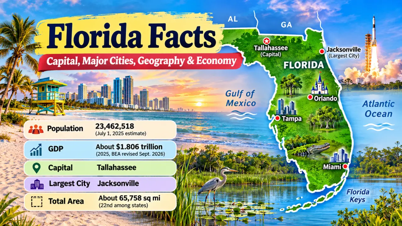
Florida is the third-most-populous U.S. state, a peninsula between the Atlantic Ocean and the Gulf of Mexico, and home to some of the country’s best-known wetlands, beaches, cities, and spaceflight facilities. Tallahassee is the capital; Jacksonville is the largest incorporated city by population. Miami, Tampa, and Orlando lead other major metropolitan and economic centers.
The U.S. Census Bureau estimated 23,462,518 Florida residents on July 1, 2025. The state’s 2025 current-dollar GDP was about $1.806 trillion, according to revised Bureau of Economic Analysis (BEA) figures released September 30, 2026. Those numbers describe two different things: how many people live in Florida and the value of economic production there.
This guide connects Florida’s physical geography with its history, settlement patterns, industries, and environmental challenges. It includes dated statistics, quick revision notes, and questions for geography, history, and economics learners.
Data reviewed: October 31, 2026. Population figures use the Census Bureau’s Vintage 2025 estimates; annual GDP figures use BEA’s September 2026 revisions.
Quick Facts About Florida
| Fact | Florida information |
|---|---|
| Official name | State of Florida |
| Abbreviation | FL |
| Nickname | Sunshine State |
| Capital | Tallahassee |
| Largest incorporated city | Jacksonville |
| U.S. region | Southeast; South Atlantic Census division |
| Statehood | March 3, 1845 – 27th state |
| Neighbors by land | Alabama and Georgia |
| Counties | 67 |
| Total area | About 65,758 square miles (Florida Department of State) |
| Land area | 53,652.17 square miles (2020 Census) |
| Total-area ranking | 22nd among states |
| Population | 23,462,518 (July 1, 2025 estimate) |
| Population ranking | 3rd (July 2025 estimate) |
| Population density | 401.4 people per square mile (2020 Census) |
| Highest natural point | Britton Hill – 345 feet |
| Largest freshwater lake | Lake Okeechobee |
| Major rivers | St. Johns, Suwannee, Apalachicola, Kissimmee |
| State bird | Northern mockingbird |
| State flower | Orange blossom |
| State tree | Sabal palm |
| State animal | Florida panther |
| Motto | In God We Trust |
| Time zones | Eastern; Central in part of the western Panhandle |
| Nominal GDP | About $1.806 trillion (2025, BEA revised September 2026) |
| GDP ranking | 4th by 2025 current-dollar state GDP |
How to read the table: The land-area and population-density values are tied to the 2020 Census. The population and GDP values refer to 2025. The Florida Department of State reports about 53,625 square miles of land using its own geographic summary, whereas the Census Bureau reports 53,652.17 square miles in its 2020 geographic dataset. These are different published measurements, not interchangeable figures. See the Florida Department of State quick facts and Census Bureau QuickFacts.
Where Is Florida Located?
Florida lies in the southeastern United States. Its main peninsula extends south between the Atlantic Ocean on the east and the Gulf of Mexico on the west. The northwestern extension, called the Florida Panhandle, follows the northern Gulf Coast toward Alabama.
Florida has land borders with just Alabama and Georgia. A Florida map shows Alabama to the northwest, Georgia to the north, the Atlantic to the east, and the Gulf to the west. At the southern end, the Florida Keys curve southwest toward the Straits of Florida. Florida has maritime connections to the Caribbean but no international land border.
For comparison, Alabama’s geography and economy include Appalachian foothills, inland manufacturing centers, and a shorter Gulf coastline. The comparison helps explain why neighboring states can have different climates, transportation networks, and settlement patterns.
How Big Is Florida?
Florida covers approximately 65,758 square miles in total area, including both land and water, and ranks 22nd by total area, according to the Florida Department of State. Its peninsula is much longer north to south than many readers expect. Traveling by road between far-western Pensacola and Key West covers hundreds of miles.
Land area excludes inland water measured separately in a statistical dataset. Total area includes land and water. A state’s rank can change depending on which measure a writer uses, so area comparisons should always name the measure and source.
Geography of Florida
Florida is mostly low and gently sloping, but it isn’t geographically uniform. Hills and river valleys characterize parts of the north; lakes and sandy ridges occur in the center; and South Florida contains vast low-lying wetlands. Limestone underlies much of the state, connecting its springs, sinkholes, groundwater, and rivers.
Main Geographic Regions
North Florida and the Panhandle contain forested uplands, streams, agricultural lands, beaches, and major river basins. The Panhandle has stronger seasonal temperature contrasts than the far south.
Central Florida includes the lake-rich interior, the Lake Wales Ridge, Orlando’s metropolitan area, and communities built around agriculture, tourism, and services. Sandy ridges and lakes reflect a long geological history of changing shorelines and water conditions.
South Florida includes low-elevation landscapes, extensive developed coastlines, Biscayne Bay, freshwater wetlands, mangroves, and the Everglades watershed. The region’s water management systems are especially consequential because its land is relatively flat.
The Florida Keys are an island chain reaching southwest from the peninsula. They support coastal communities, marine habitats, and reef environments. Key West is a city, not Florida’s capital or its southernmost point of land overall.
Britton Hill, Limestone, and Springs
Britton Hill in Walton County is Florida’s highest natural point at about 345 feet above sea level. Florida therefore has the lowest highest point of any U.S. state. That doesn’t mean every place is at sea level; northern hills and central ridges stand above nearby plains.
Many Florida landscapes are shaped by karst, a type of terrain produced as slightly acidic water dissolves soluble rock such as limestone. Over time, underground cavities can develop. Some collapse into sinkholes; others contribute to caves, springs, and channels through which groundwater moves.
Florida’s limestone aquifers are important sources of freshwater, but groundwater systems can be affected by pollution, excessive pumping, and saltwater intrusion near some coasts.
Rivers, Lakes, and Lake Okeechobee
The St. Johns River flows generally north through eastern Florida toward Jacksonville and the Atlantic. The Suwannee River begins in southern Georgia and enters Florida before reaching the Gulf. The Apalachicola River is important to the Panhandle, while the Kissimmee River connects with the Lake Okeechobee watershed.
Lake Okeechobee is Florida’s largest freshwater lake by surface area. Water management around the lake affects surrounding communities, agriculture, flood control, and ecosystems to the south. It is part of a much larger connected watershed rather than an isolated attraction.
How the Everglades Work
The Everglades are often called a “River of Grass” because shallow freshwater historically moved slowly through broad sawgrass marshes and connected habitats. This is not a single narrow river channel. It is a landscape-scale system involving water, plants, soil, seasons, and animals.
Seasonal rainfall and water flow support marshes, tree islands, mangroves, and habitats for wading birds, alligators, crocodiles, fish, and mammals. Canals, roads, drainage, farming, and urban development changed the historical flow of water. Restoration projects seek to improve water timing, distribution, and quality.
Everglades National Park protects only part of the wider Everglades ecosystem. For context, consult the National Park Service’s Everglades resources.
Coastline, Islands, and Natural Hazards
Florida has Atlantic and Gulf coastlines, offshore islands, barrier beaches, tidal flats, mangrove forests, and estuaries. An estuary is a coastal area where freshwater mixes with saltwater. These environments are important nurseries for fish and wildlife.
Coastline lengths vary with the measuring method: a straightened coast is much shorter than a measurement that follows islands, inlets, and tidal shorelines. Use a specific official definition before comparing Florida’s coastline with that of another state.
Low elevations and coastal development expose some communities to tidal flooding, storm surge, erosion, and saltwater intrusion. Inland flooding and karst-related sinkholes create different risks. Environmental conditions are therefore best understood region by region.
What Is the Capital of Florida?
Tallahassee is the capital of Florida. It is in Leon County in North Florida, near the Georgia border. The city houses the state government and institutions including Florida State University and Florida A&M University.
Why Tallahassee Became the Capital
During Florida’s early territorial period, government business had been associated with St. Augustine in the east and Pensacola in the west. Traveling between those centers was difficult. In 1824, Tallahassee was selected as a more practical seat of territorial government. It remained the capital when Florida entered the Union in 1845.
Tallahassee’s estimated July 1, 2025 city population was 204,902 (U.S. Census Bureau). It is not Florida’s largest city. Jacksonville has the largest incorporated city population, whereas Miami anchors the state’s largest metropolitan concentration. The difference between a capital, an incorporated city, and a metropolitan area is essential for interpreting population facts.
Major Cities in Florida
Florida’s major cities have different roles: Tallahassee concentrates state government, Miami connects international business networks, Orlando supports a major visitor economy, and Jacksonville and Tampa have major logistics and service industries.
| Incorporated city | Population estimate, July 1, 2025 | Why it matters |
|---|---|---|
| Jacksonville | 1,017,689 | Port, logistics, finance, healthcare |
| Miami | 489,812 | International trade, finance, culture |
| Tampa | 413,554 | Port, healthcare, finance, services |
| Orlando | 333,888 | Tourism, conventions, technology |
| Port St. Lucie | 268,062 | Growing Treasure Coast city |
| St. Petersburg | 264,033 | Tampa Bay services, arts, tourism |
| Hialeah | 230,968 | Major Miami-area incorporated city |
| Tallahassee | 204,902 | Government and higher education |
Population figures are Census Bureau Vintage 2025 estimates for city boundaries. The table selects prominent cities, not an exhaustive statewide ranking.
Jacksonville
Jacksonville stands near the mouth of the St. Johns River in northeastern Florida. Its port and transportation networks support cargo movement, warehouses, distribution, and industries that depend on access to domestic and international markets. Healthcare, financial services, and professional employment also matter. Jacksonville’s city boundaries cover a very large area, so population comparisons should not be confused with regional economic size.
Miami
Miami is a major center for trade, finance, tourism, aviation, and cultural exchange with Latin America and the Caribbean. Miami city proper is smaller than Jacksonville, but the wider Miami-Fort Lauderdale-West Palm Beach metropolitan region is much larger than either city proper. Its international airports, seaport facilities, businesses, and diverse communities contribute to its economic importance.
Tampa and St. Petersburg
Tampa sits on the Gulf side of Florida and forms part of the broader Tampa Bay region with St. Petersburg and Clearwater. The area supports healthcare, banking, technology-related services, maritime activity, tourism, and shipping. Port Tampa Bay is an important regional transportation asset.
Orlando
Orlando is associated with major theme parks and conventions, but its economy also includes healthcare, university education, engineering, and professional services. Large attractions such as Walt Disney World Resort are in the greater Orlando area, not necessarily inside Orlando’s municipal boundaries.
Other Important Cities
Port St. Lucie has seen rapid population growth along the Treasure Coast; its 2025 estimate was about 30.9% above the Census Bureau’s April 2020 estimates base. Fort Lauderdale has maritime, travel, and service industries. Gainesville is an academic and research center. Pensacola has a long Gulf Coast and naval-aviation history. Key West is important for the cultural and maritime history of the Keys.
Population of Florida
The Census Bureau counted 18,801,310 people in Florida in April 2010 and 21,538,187 in April 2020. Its July 1, 2025 population estimate was 23,462,518. Counts and estimates are produced in different ways; estimates can be revised as more information becomes available.
| Measurement | Population | Type |
|---|---|---|
| April 1, 2010 | 18,801,310 | Decennial Census count |
| April 1, 2020 | 21,538,187 | Decennial Census count |
| July 1, 2025 | 23,462,518 | Vintage 2025 estimate |
In the same Vintage 2025 estimates, Florida was third in population, after California and Texas and ahead of New York State. Read the Census Bureau’s state QuickFacts to distinguish the latest estimates from older enumerations.
Why Population Growth Is Uneven
Florida’s growth reflects births, deaths, domestic migration, and international migration. Jobs, family connections, retirement decisions, and housing costs influence where people move, but no single factor explains the state’s changing population.
Growth also differs among counties and cities. Port St. Lucie and parts of Central and Southwest Florida have expanded rapidly, while established municipalities can grow more slowly. A state’s rising total doesn’t mean every city is gaining residents.
City Population, Metro Population, and Density
A city-proper population covers people living within legal municipal boundaries. A metropolitan population covers a larger area defined through economic and commuting connections. These measures answer different questions.
Population density is population divided by land area. Florida’s 2020 Census density was 401.4 residents per square mile; using the 2025 state estimate with the 2020 land-area figure would produce a different, mixed-period calculation. Do not present those two densities as the same measurement.
Florida’s population patterns can be compared with California and New Jersey to explore how urban density, state size, and coastal development differ across the country.
Climate and Weather in Florida
Florida is generally warm, but northern, central, and southern areas do not share identical weather. Much of the state has a humid subtropical climate; parts of the far south have a tropical climate.
North Florida experiences cooler winters and occasional freezing temperatures. South Florida generally remains warmer in winter. Summers across much of the state are hot, humid, and associated with thunderstorms, although rainfall amounts vary by season and place.
Rainfall, Wet Seasons, and Water Supply
Sea breezes and afternoon heating contribute to frequent summer storms in many areas. Southern Florida has especially pronounced seasonal changes in rainfall. These patterns influence farming, water supply, wetlands, and the timing of freshwater flows through the Everglades.
Hurricane Season and Flooding
According to NOAA, the Atlantic hurricane season runs from June 1 to November 30. Tropical cyclones can occur outside those dates, and impacts vary by location and storm. Hazards include high winds, heavy rainfall, tornadoes, storm surge, and coastal flooding.
Storm surge is ocean water pushed onto land by a storm; it is different from the rainfall flooding that can occur well inland. A coastal city and an inland community may face different risks from the same hurricane. The NOAA National Hurricane Center explains hurricane-season climatology.
Climate and Coastal Change
Sea-level rise can increase the frequency of tidal flooding and make storm surge reach farther inland in susceptible areas. Saltwater intrusion can affect groundwater supplies and ecosystems. Land elevation, drainage, local geology, and infrastructure influence which Florida communities are most vulnerable.
Economy of Florida
Florida’s economy is large and diverse. Tourism is highly visible but is not the whole economy. Real estate, healthcare, professional services, finance, retail and wholesale trade, construction, logistics, agriculture, technology, manufacturing, and aerospace all contribute to economic activity.
The state’s location helps explain several industries. Coasts and warm weather support visitor activity; ports connect businesses to international markets; population growth creates demand for homes, hospitals, transport, and services; and the Space Coast supports government and commercial aerospace operations.
Tourism and Hospitality
VISIT FLORIDA reported a revised estimate of about 143.33 million visitor trips in calendar year 2025, released in 2026. This counts estimated visitor trips, not necessarily 143.33 million unique people. Hotels, restaurants, airports, beaches, theme parks, cruises, conventions, and cultural destinations benefit from visitor spending.
Tourism figures need careful interpretation. Visitor counts, visitor spending, tourism employment, and industry GDP are different measures. A large visitor count alone doesn’t establish a particular share of total state GDP. See VISIT FLORIDA’s visitor research.
Agriculture and Food Production
Florida is associated with oranges, but its farms produce much more. Major products include strawberries, tomatoes, sugarcane, sweet corn, citrus, nursery plants, cattle, and ornamental horticulture products. Farming takes place in several regions under different growing conditions.
The Florida Department of Agriculture, citing USDA statistics, reported 44,400 farms and ranches using 9.7 million acres in 2024. A 2024 agricultural production measure should not be mixed without explanation with a GDP figure for 2025. The state’s citrus industry has faced disease and other production challenges, making historical reputation different from a present-day production ranking. See official Florida agriculture statistics.
Ports, Aviation, and International Trade
PortMiami, Port Everglades, Port Tampa Bay, and JAXPORT handle different combinations of cargo, cruises, and maritime services. International airports support passengers, air freight, and related business activity. Florida’s location is particularly useful for trade and travel involving the Caribbean and Latin America.
Aerospace, Spaceflight, and Defense
NASA’s Kennedy Space Center on Merritt Island supported Apollo-era missions and the Space Shuttle program. The surrounding Space Coast includes launch operations, engineering, contractors, research, and commercial aerospace businesses. Florida also has military installations and aviation industries elsewhere in the state.
Space exploration is part of Florida’s economic and educational identity, but launch activity is only one part of the wider aerospace and defense sector.
Finance, Healthcare, Construction, and Services
Major metropolitan areas concentrate hospitals, universities, banks, insurance businesses, technology firms, law firms, and other services. Construction and real estate are especially visible where communities are growing. Miami’s international finance connections differ from Orlando’s tourism and convention economy or Jacksonville’s logistics businesses.
For a labor-market snapshot, the U.S. Bureau of Labor Statistics reported Florida’s preliminary seasonally adjusted unemployment rate at 4.4% in September 2026. That rate describes unemployed people as a share of the labor force, not everyone without a job. The BLS September 2026 state employment report provides the measure and its limitations.
GDP of Florida
Florida’s nominal gross domestic product (GDP) was $1,805.6 billion, or about $1.806 trillion, in calendar year 2025, according to the BEA’s annual state GDP figures revised September 30, 2026. It was the fourth-largest state economy by current-dollar GDP, after California, Texas, and New York.
GDP estimates the value added by production within an economy. It isn’t the government’s budget, the sum of salaries, or total sales receipts. GDP helps compare economic scale, but it does not tell us by itself how prosperous each household is.
Nominal GDP vs. Real GDP
Nominal GDP uses the prices prevailing in each year. Real GDP adjusts for changes in prices to make growth in production easier to compare. BEA’s real-dollar series is expressed in chained 2017 dollars, a statistical adjustment rather than the amount of money physically exchanged.
| Annual economic measure | 2024 | 2025 |
|---|---|---|
| Nominal GDP, current dollars | $1,706.2 billion | $1,805.6 billion |
| Real GDP, chained 2017 dollars | $1,338.8 billion | $1,376.7 billion |
| Real GDP growth from prior year | – | About 2.8% for 2024-2025 |
BEA annual series, revised September 30, 2026. Values rounded. Nominal GDP: FLNGSP; real GDP: FLRGSP, as distributed by the Federal Reserve Bank of St. Louis.
The difference between $1.706 trillion and $1.806 trillion in nominal GDP includes both price and production changes. Comparing the revised real GDP series suggests approximately 2.8% growth in inflation-adjusted output from 2024 to 2025.
GDP Per Resident Is Not Personal Income
Dividing 2025 nominal GDP by the July 1, 2025 population estimate gives about $76,960 in annual economic output per resident (rounded). This is an illustrative ratio of GDP to population, not a measure of average pay or median household income. Some production is connected to businesses, capital, visitors, and institutions, so GDP per resident cannot be interpreted as the typical resident’s earnings.
For comparison, the Census Bureau reports Florida’s median household income as $74,568 in 2024 dollars for the 2020-2024 American Community Survey period. The two numbers have different definitions and reference periods; they should not be placed side by side as if they measure the same thing.
Which Industries Add the Most Value?
GDP by industry measures value added, not simply the number of customers or a company’s total revenue. Broad sectors include real estate, professional services, finance, healthcare, trade, manufacturing, construction, transportation, hospitality, and government. Without a matching BEA industry breakdown, it would be misleading to claim that tourism is the largest contributor to Florida GDP merely because tourism is famous.
Official definitions and releases are available from BEA’s GDP by State, with the revised historical series in Florida nominal GDP and Florida real GDP.
Brief History of Florida
Florida’s history did not begin with European exploration. Indigenous peoples lived in the region for at least 14,000 years, according to the Florida Department of State, adapting to its changing coasts, rivers, forests, and wetlands.
Indigenous Peoples and Early Communities
The Timucua, Calusa, and Apalachee were among the historically documented Indigenous peoples of the area. Their societies differed in language, political organization, subsistence, and settlement patterns. Later Seminole and Miccosukee histories developed through migration, resistance, cultural continuity, and changing relationships with colonial and U.S. governments. Seminole and Miccosukee communities remain part of Florida today.
European Exploration and Colonial Florida
Juan Ponce de León’s 1513 expedition is an early documented Spanish encounter with Florida, not the beginning of human history there. Spain established St. Augustine in 1565, now recognized as the oldest continuously occupied European-founded settlement in the continental United States.
British control began in 1763, and Florida returned to Spanish control in 1783. The region’s history involved Indigenous diplomacy and resistance, enslaved and free African-descended communities, European colonial authorities, and shifting territorial boundaries.
Territory, Seminole Wars, and Statehood
The 1819 Adams-Onís Treaty provided for Spain’s cession of Florida, and the transfer was completed in 1821. Congress organized Florida Territory in 1822. Tallahassee became its capital in 1824.
U.S. expansion brought warfare and coercive displacement, particularly during the Seminole Wars. Many Seminole people were forced west, while others remained in Florida and continued their communities. These experiences are central to the history of the state, not a minor footnote.
Florida joined the Union on March 3, 1845, as the 27th state. For the broader national context, see How Many States Are in the United States of America?. Parts of its antebellum economy relied on plantation agriculture and the labor of enslaved African Americans.
Civil War, Reconstruction, and Modern Growth
Florida seceded from the Union in 1861 and joined the Confederacy. After the Civil War, emancipation and Reconstruction brought fundamental political changes, although racial discrimination and barriers to equal rights continued. Florida also became a setting for important twentieth-century civil rights activity.
Railroads, farming, tourism, land speculation, and transportation changed Florida after the nineteenth century. A land boom in the 1920s was followed by economic disruption. World War II increased the state’s military and aviation importance, while postwar migration, air conditioning, highways, and new industries accelerated population growth. The Space Coast became closely associated with NASA’s space program.
The Florida Department of State’s historical overview provides a useful chronology for further study.
Government and Education in Florida
Florida has an elected governor, a two-chamber legislature with a Senate and House of Representatives, and a state court system. It is divided into 67 counties, with local governments responsible for many community services. Tallahassee is the seat of state government.
Public schooling is administered through school districts and state-level education structures. Higher education includes the University of Florida in Gainesville, Florida State University and Florida A&M University in Tallahassee, University of Central Florida in Orlando, University of South Florida in Tampa, and Florida International University in Miami. The University of Miami is a private university with major research and healthcare connections.
These institutions connect Florida to research in agriculture, medicine, marine science, environmental protection, aerospace, engineering, and many other fields.
Famous Places and Landmarks in Florida
| Place | Educational significance |
|---|---|
| Everglades National Park | Wetlands, freshwater flow, wildlife, conservation |
| Florida Keys | Island chains, coral-reef environments, maritime history |
| Kennedy Space Center | Apollo, Space Shuttle, and spaceflight history |
| St. Augustine | Spanish colonial history beginning in 1565 |
| Castillo de San Marcos | Colonial fortifications and military history |
| Biscayne National Park | Marine ecosystems and coastal conservation |
| Dry Tortugas National Park | Fort Jefferson, islands, reefs, maritime history |
| Canaveral National Seashore | Barrier-island habitats and coastal protection |
| Walt Disney World Resort area | Tourism, employment, and regional economic geography |
Everglades National Park helps students examine how water and ecosystems shape a landscape. Kennedy Space Center connects physical location to technology and national history. St. Augustine and Castillo de San Marcos illustrate the long colonial period before Florida became a state. Dry Tortugas and Biscayne national parks show that conservation may focus on marine habitats, not only forests or mountains.
See the National Park Service’s Florida park inventory for official site information.
State Symbols of Florida
Florida’s official symbols reflect its plants, animals, agriculture, and identity. These are state designations, not merely objects commonly associated with Florida.
| Official designation | Symbol |
|---|---|
| State bird | Northern mockingbird |
| State flower | Orange blossom |
| State tree | Sabal palm |
| State animal | Florida panther |
| State reptile | American alligator |
| State marine mammal | Manatee |
| State butterfly | Zebra longwing |
| State wildflower | Coreopsis |
| State beverage | Orange juice |
| State shell | Horse conch |
| State motto | In God We Trust |
The orange blossom relates to citrus agriculture, the sabal palm to Florida’s native vegetation, and the manatee to freshwater and coastal habitats. The Florida panther also draws attention to conservation and habitat protection. For other official designations, consult the Florida Department of State’s symbols list.
15 Interesting Facts About Florida
- Florida has the lowest highest natural point of any U.S. state. Britton Hill rises only about 345 feet, making elevation a distinctive geographic fact.
- The St. Johns River generally flows north. Its course challenges the mistaken idea that every river flows south.
- The Everglades are a broad wetland system, not one narrow river. Their water movement connects lakes, marshes, and coastal habitats.
- Florida combines a northern Panhandle and a long southward peninsula. That shape helps explain its two coastlines and long travel distances.
- Tallahassee became the capital in 1824, before Florida was a state. It was chosen during the territorial period.
- Jacksonville’s city population passed one million in the 2025 Census estimates. Population comparisons depend on legal boundaries.
- Florida was the third-most-populous state in July 2025. Its state population rank differs from its fourth-place GDP rank.
- Lake Okeechobee helps regulate water across South Florida. Decisions about its water levels affect people and ecosystems.
- The Florida Keys are islands, not one continuous landmass. Roads and bridges connect many of their communities.
- St. Augustine dates to a Spanish settlement founded in 1565. Indigenous histories in the region extend much further back.
- Kennedy Space Center supported Apollo and Space Shuttle missions. Florida’s aerospace connections span both public and commercial activity.
- Florida contains part of the Atlantic coast’s tropical climate zone. Its northern districts have cooler winters than the south.
- Agriculture is wider than orange production. Florida produces vegetables, sugarcane, nursery crops, and livestock.
- Tourism data count trips rather than automatically counting unique individuals. The distinction matters when comparing visitor statistics.
- Real GDP and nominal GDP answer different questions. Price adjustment matters when studying how quickly an economy grows.
Florida Facts for Students: Quick Review
| Review question | Answer |
|---|---|
| Florida’s capital? | Tallahassee |
| Largest incorporated city? | Jacksonville |
| Postal abbreviation? | FL |
| U.S. region? | Southeast |
| Statehood date and order? | March 3, 1845; 27th |
| Neighboring states? | Alabama and Georgia |
| Population in July 2025 estimate? | 23,462,518 |
| Population rank in July 2025? | Third |
| Highest natural point? | Britton Hill, about 345 feet |
| Largest freshwater lake? | Lake Okeechobee |
| Best-known major wetland system? | Everglades |
| Official flower? | Orange blossom |
| Official bird? | Northern mockingbird |
| 2025 nominal GDP? | About $1.806 trillion |
| 2025 nominal GDP rank? | Fourth |
| Atlantic hurricane season? | June 1-November 30 |
Remember three distinctions: Tallahassee is the capital, Jacksonville is the largest incorporated city, and Miami is the principal city of Florida’s largest metropolitan region. A 2020 Census count is not a 2025 estimate, and GDP per resident is not household income.
Florida MCQ Quiz – Test Your Knowledge
Which state borders northwestern Florida?
Florida shares its northern land border with which state?
Which sequence correctly distinguishes the treaty and transfer of Florida to U.S. control?
How long before Florida’s 1845 statehood was Tallahassee selected as territorial capital?
Which historical sequence for Florida is correct?
Which colonial sequence accurately describes Florida in the late eighteenth century?
Why did both Pensacola and St. Augustine influence Florida’s choice of territorial capital?
A researcher compares Florida with Georgia by population. Which approach best avoids a vintage mismatch?
When constructing a Florida population time series, which distinction must be documented?
Why could three Florida urbanization studies reach different results?
What is essential when interpreting Jacksonville’s large city-proper population?
Why would Miami’s city-only employment data understate its wider urban economy?
How should researchers compare population density in two Florida regions?
What should an analyst do with two different official Florida land-area measures?
Which practice strengthens reproducibility of a Florida GDP time-series study?
Frequently Asked Questions About Florida
What is Florida known for?
Florida is known for the Everglades, the Florida Keys, beaches, tourism destinations, historic St. Augustine, and Kennedy Space Center. Its economy also includes healthcare, agriculture, finance, trade, technology, and other services.
What is the capital of Florida?
Tallahassee is Florida’s capital. It was designated the territorial capital in 1824 and remained the capital after statehood in 1845.
What is the largest city in Florida?
Jacksonville is Florida’s largest incorporated city by population, with 1,017,689 residents estimated on July 1, 2025. Miami anchors a larger metropolitan area, which is a different geographic measure.
What are the major cities in Florida?
Jacksonville, Miami, Tampa, Orlando, St. Petersburg, Port St. Lucie, Hialeah, and Tallahassee are among Florida’s important incorporated cities. Fort Lauderdale, Gainesville, Pensacola, and other communities have distinctive regional roles.
What is Florida’s population?
The U.S. Census Bureau estimated 23,462,518 residents on July 1, 2025, ranking Florida third in the United States in that estimates series.
What is Florida’s GDP?
Florida’s 2025 current-dollar GDP was approximately $1.806 trillion in the BEA annual series revised September 30, 2026. Nominal GDP measures the value of production at current prices.
What are Florida’s major industries?
Important industries include professional and business services, real estate, healthcare, trade, finance, construction, manufacturing, transportation, tourism, agriculture, and aerospace. A sector’s public visibility is not necessarily its GDP ranking.
Where is Florida located?
Florida is in the southeastern United States, between the Atlantic Ocean and Gulf of Mexico. Its western Panhandle extends along the Gulf Coast, and the Florida Keys extend southwest of the main peninsula.
Which states border Florida?
Alabama and Georgia are Florida’s two neighboring states by land.
When did Florida become a state?
Florida became the 27th U.S. state on March 3, 1845, after earlier Spanish, British, and U.S. territorial periods.
Why is Florida called the Sunshine State?
The nickname reflects Florida’s association with warm weather and sunshine. It doesn’t mean every part is sunny year-round; the state also experiences heavy rainfall, thunderstorms, and hurricanes.
What is the highest point in Florida?
Britton Hill in Walton County, at approximately 345 feet above sea level, is Florida’s highest natural point.
What is Florida’s climate like?
Much of Florida is humid subtropical, while parts of far southern Florida are tropical. North Florida has cooler winters, and much of the state experiences summer rain and thunderstorms.
Conclusion
Florida’s facts make more sense when considered together. Its long peninsula helps explain international trade and exposure to coastal storms. Limestone and low elevations help explain its springs, wetlands, water-management challenges, and distinctive landscapes. Population growth has influenced its cities and demand for services, while its history includes Indigenous communities, colonization, statehood, civil rights struggles, and the rise of spaceflight and modern industries.
For a quick exam answer, remember: Tallahassee is the capital, Jacksonville is the largest incorporated city, Florida became a state in 1845, and its July 2025 population estimate was 23,462,518. For deeper study, distinguish population measures, economic output, and the different systems that connect Florida’s environment and economy.
Sources and Data Notes
- U.S. Census Bureau – Florida QuickFacts – 2010 and 2020 Census counts, July 2025 population estimate, land area, density, and 2020-2024 household income.
- U.S. Census Bureau – City and Town Population Estimates, 2020-2025 – Vintage 2025 incorporated-city estimates, released May 2026.
- Florida Department of State – Quick Facts – total area, statehood, counties, and geographic facts.
- Florida Department of State – A Brief History – Indigenous, colonial, territorial, and state history.
- Florida Department of State – State Symbols – official designations.
- U.S. Bureau of Economic Analysis – GDP by State – state GDP definitions and September 30, 2026 release.
- BEA via FRED – Florida Nominal GDP, FLNGSP and Florida Real GDP, FLRGSP – annual series revised September 30, 2026; current-dollar and chained 2017-dollar values.
- U.S. Bureau of Labor Statistics – September 2026 State Employment and Unemployment – preliminary seasonally adjusted unemployment rate.
- Florida Department of Agriculture – Agricultural Overview – 2024 farms and land in farms.
- VISIT FLORIDA – Visitor Research – revised calendar-year 2025 visitor trips estimate, announced in 2026.
- National Park Service – Everglades National Park and Florida National Park Sites – ecology, landscapes, and parks.
- NOAA National Hurricane Center – Climatology – Atlantic hurricane season.
Editorial data note: Figures are tied to the periods stated. Census estimates and BEA accounts are subject to subsequent revision. Where official agencies publish slightly different land-area measurements, the article identifies the source instead of treating them as directly interchangeable. Facts and source links reviewed October 31, 2026.