
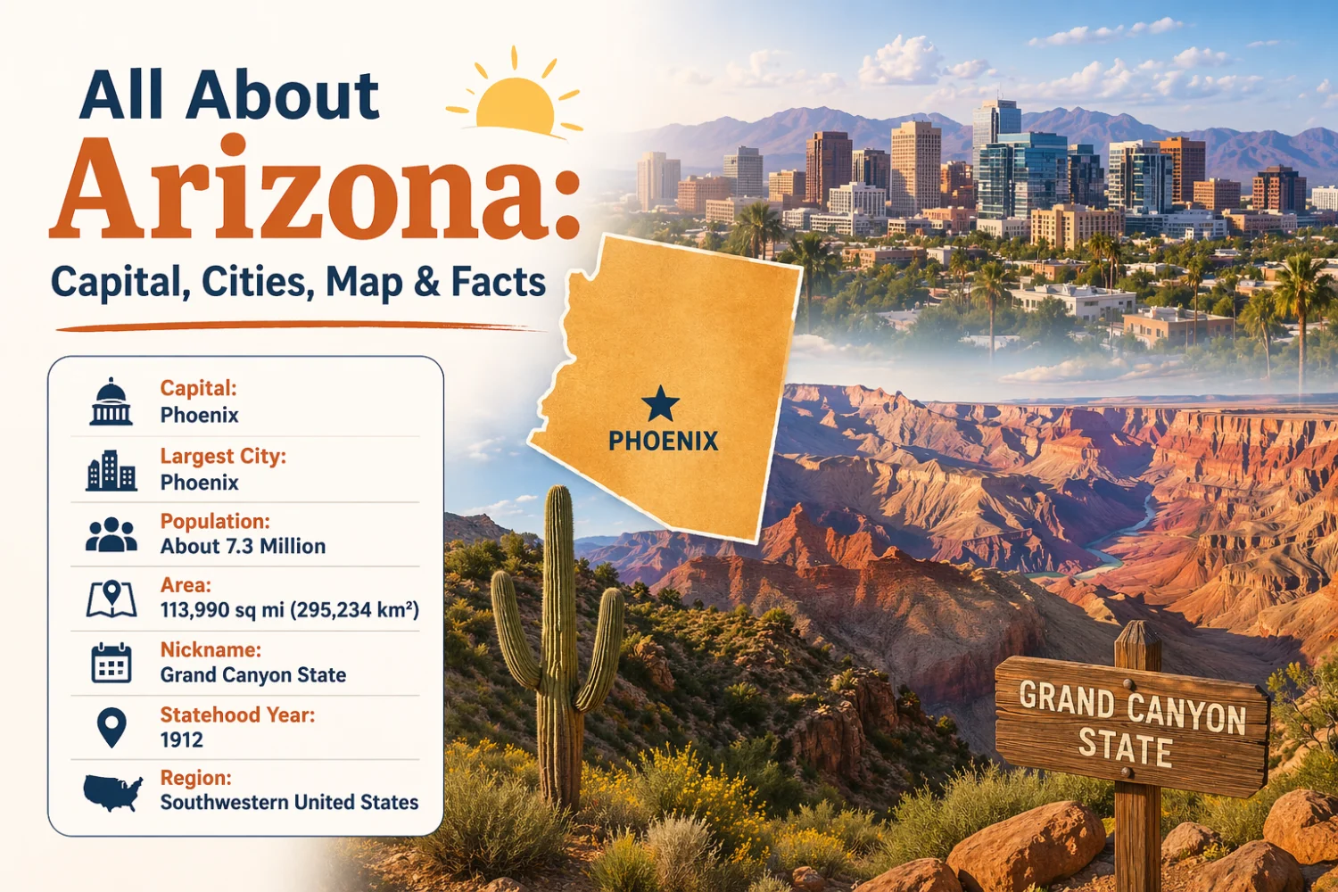
Quick Facts about Arizona
- Capital city: Phoenix
- Largest City: Phoenix
- Population: About 7.3 million (estimate)
- Area: 113,990 sq mi (295,234 km²)
- Nickname: Grand Canyon State
- Statehood Year: 1912
- Region: Southwestern United States
Introduction
Arizona is a U.S. state in the southwestern region known for its dramatic desert landscapes, high plateaus and the Grand Canyon. The state combines significant Native American history, rapid urban growth in its lowland valleys, and extensive federally managed public lands. Arizona’s economy relies on sectors such as mining, manufacturing, tourism and technology, while its environments range from hot Sonoran Desert basins to snow-covered mountain peaks.
Location of Arizona
Arizona is located in the southwestern United States. It occupies part of the country’s western interior and extends to the international border with Mexico.
The state borders California to the west, Nevada to the northwest, Utah to the north, Colorado at a single point in the northeast (the Four Corners), and New Mexico to the east. To the south it shares an international border with the Mexican state of Sonora.
Arizona’s positioning places it at a geographic crossroads: it connects the Pacific Coast states with the interior Southwest and provides a southern border gateway to Mexico. The Four Corners region, where Arizona meets Utah, Colorado and New Mexico, is unique in the United States.
Capital of Arizona
Phoenix
Phoenix is the state capital and the largest city in Arizona. It serves as the seat of state government and the primary commercial, financial and cultural center in the region.
Key facts about Phoenix: it is the central city of the Phoenix metropolitan area, one of the nation’s largest metro regions by population. Phoenix functions as a major transportation hub, has a diversified economy that includes manufacturing, technology and services, and is a center for state government agencies and higher education institutions.
The city is located in the Salt River Valley and sits within the Sonoran Desert, which influences its urban development, water management and climate considerations.
Largest Cities in Arizona
This section profiles major population and economic centers beyond the state capital.
Phoenix
Phoenix is the largest city by population and the chief metropolitan center. It hosts state government offices, regional healthcare systems, and a broad service and manufacturing base. The city’s growth since the mid‑20th century has reshaped the state’s economy and infrastructure.
Tucson
Tucson is the second‑largest city, located about 100 miles southeast of Phoenix. It is home to the University of Arizona and a cluster of research institutions, with strong aerospace, optics and defense sectors. Tucson is surrounded by mountain ranges and is a cultural center for southern Arizona.
Mesa
Mesa is an eastern suburb of Phoenix and one of the state’s largest cities. It has significant light manufacturing, technology employers and an expanding service sector. Mesa’s local economy and residential growth reflect the broader expansion of the Phoenix metropolitan area.
Chandler
Chandler is a major technology and business hub within the Phoenix metro area. It hosts semiconductor and software firms, business parks and growing residential communities. Chandler’s economy emphasizes high‑tech manufacturing and professional services.
Flagstaff
Flagstaff is a smaller city in northern Arizona at high elevation near the San Francisco Peaks. It functions as a regional center for tourism, outdoor recreation, higher education (Northern Arizona University) and scientific research due to nearby observatories and national forest lands.
Geography of Arizona
Arizona’s geography is varied and includes deserts, plateaus, mountains and river valleys. Three major physiographic provinces dominate the state:
- Colorado Plateau in the north: a high, arid plateau marked by canyons, mesas and extensive sedimentary formations.
- The Basin and Range province in the west and south: characterized by alternating mountain ranges and valleys.
- The Sonoran Desert in the southwest and central lowlands: a biologically diverse desert with iconic vegetation such as the saguaro cactus.
Major rivers include the Colorado River, which forms part of Arizona’s western boundary and supplies critical water to the region, and the Gila River, which drains central and southwestern areas. The Salt River flows through the Phoenix area and is important for local water storage and irrigation.
Primary lakes and reservoirs formed by damming the Colorado River include Lake Powell (Glen Canyon Dam), Lake Mead (Hoover Dam, on the Nevada–Arizona border) and Lake Havasu. These reservoirs support water supplies, hydroelectric power and recreation.
Mountain ranges and forests are prominent in higher elevations: the San Francisco Peaks near Flagstaff include Humphreys Peak, Arizona’s highest point. National forests such as Coconino, Kaibab and Apache‑Sitgreaves cover large tracts of northern and eastern Arizona.
Arizona has no coastline. Its terrain and river systems play central roles in water resource management, land use and ecosystem diversity.
Climate of Arizona
Arizona’s climate varies with elevation. Much of the state has an arid to semi‑arid climate, while higher elevations experience temperate and alpine conditions.
Lowland areas, including Phoenix and Tucson, have hot desert climates with very hot summers and mild winters. Summers often exceed 100°F (38°C) in the lower basins.
Northern and highland areas have cooler summers and significant winter snowfall. Flagstaff and the higher mountains have a mountain climate, with winter temperatures frequently below freezing and snow cover on peaks.
Arizona experiences two primary precipitation patterns: winter frontal storms that bring moisture to the northern and higher regions, and the North American monsoon in summer (typically July through September). The monsoon delivers thunderstorms that produce short but intense rainfall, localized flooding and increased humidity.
Average annual rainfall varies widely: desert basins may receive less than 10 inches (250 mm) per year, while mountain regions can receive several times that amount. Overall, water scarcity and variability are important climatic challenges for the state.
Interesting Facts About Arizona
- Home to the Grand Canyon National Park, one of the world’s most recognized natural landmarks and a UNESCO World Heritage Site.
- Arizona became the 48th state on February 14, 1912, the last of the contiguous states to join the Union.
- The Navajo Nation, the largest Native American reservation in the U.S., covers portions of northeastern Arizona and extends into Utah and New Mexico.
- Arizona leads the United States in copper production and has a long history of mining other minerals.
- The saguaro cactus, an iconic symbol of the American Southwest, grows naturally only in the Sonoran Desert region of southern Arizona and nearby areas.
- Most of Arizona observes Mountain Standard Time year‑round and does not participate in daylight saving time; the Navajo Nation observes daylight saving time.
- Arizona contains part of the Colorado River watershed, a critical water source for multiple states and large metropolitan areas in the Southwest.
- Flagstaff area hosts important astronomical observatories; its high elevation and dark skies make it a center for astronomical research.